Your experience hiking in the UK is valuable, but it won’t fully prepare you for the unique, ‘saturated environment’ of the Pacific Northwest’s rainforests, where standard gear and techniques often fail.
- Navigation is compromised: Heavy canopy blocks GPS, and local geology can disable digital compasses.
- Gear failure is common: Constant dampness, not just rain, causes boot delamination and negates the effectiveness of ‘water-resistant’ jackets.
- Environmental risks are counter-intuitive: You can become dehydrated in cool, humid conditions, and wildlife encounters require specific local knowledge.
Recommendation: Shift your mindset from preparing for rain to preparing for a constant state of wetness. This means upgrading key gear, adopting a robust analogue navigation system, and understanding the local environmental rules.
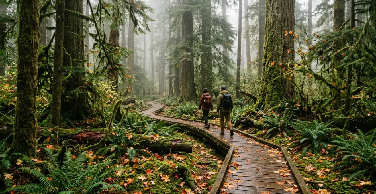
As a guide based in Seattle, but originally from the UK, I see the same look on the faces of British hikers every autumn. It’s a look of awe at the sheer scale of the Pacific Northwest rainforests, quickly followed by a dawning realisation: this isn’t the Lake District. The skills you’ve honed on Scafell Pike or in the Scottish Highlands are a brilliant foundation, but they don’t fully translate to an environment that operates under a different set of rules. The key mistake isn’t a lack of experience, but an underestimation of what a truly saturated environment does to your gear, your body, and your navigation tools.
Many guides will tell you to pack waterproofs and watch for wildlife. That’s the easy part. What they often fail to explain is *why* your expensive ‘waterproof’ boots might fall apart after two days on the Hoh River Trail, or why your reliable phone GPS will become a useless brick under the dense canopy. This isn’t about simply staying dry from a downpour; it’s about surviving and thriving in a world where the air, the ground, and the trees themselves are perpetually damp. This guide is built on that local knowledge, designed to bridge the gap between your solid British hillwalking skills and the specific challenges of Washington and Oregon’s temperate rainforests.
We’re going to move beyond the platitudes and into the practical mechanics of PNW safety. We’ll explore why getting lost is so easy here, how to manage the real wildlife risks, and why your sense of timing is more critical than ever. By the end, you won’t just have a packing list; you’ll have a new mindset for tackling one of the most beautiful and deceptively demanding landscapes on Earth.
This article breaks down the essential mindset shifts and practical skills you’ll need. We’ll cover everything from the navigation errors that catch people out to the specific gear choices that separate a comfortable trip from a miserable, dangerous one.
In This Guide: Navigating America’s Most Challenging Rainforests
- The Trail Navigation Mistake That Gets Tourists Lost in Dense Oregon Woods
- How to Spot and Safely Avoid Dangerous Wildlife Encounters in the Pacific Northwest?
- Olympic National Park or Mount Hood: Which Rainforest Route Offers Better Trails?
- When to Start Your Forest Hike to Avoid the Treacherous Afternoon Fog?
- Why Standard Hiking Apps Often Fail Completely Under Heavy US Rainforest Canopies?
- The Cheap Footwear Error That Causes Severe Blisters on Wet American Trails
- The Water Rationing Error That Causes Dozens of Desert Rescues Every Summer
- Which Waterproof Gear Should You Pack for Demanding US National Park Hikes?
The Trail Navigation Mistake That Gets Tourists Lost in Dense Oregon Woods
The most common mistake visitors make is placing absolute faith in a single, digital navigation tool. Back home, an Ordnance Survey map on your phone might be perfectly adequate. Here, it’s a recipe for disaster. The primary issue is what we call the ‘Canopy Effect’. The sheer density of the evergreen canopy in places like the Olympic Peninsula is so thick that it consistently blocks GPS signals. Your phone, constantly searching for a signal it can’t find, will drain its battery at an alarming rate, leaving you with a dead device far from the trailhead.
Furthermore, the forest floor itself is a web of what appear to be trails. In autumn, a thick carpet of fallen leaves completely obscures the official path, while trails created by herds of elk look just as, if not more, inviting. The National Park Service has documented how even experienced hikers are lured onto these false trails in the Hoh Rainforest, which can lead them deep into the wilderness or towards river crossings that become suddenly impassable after a storm. This isn’t about carelessness; it’s about a landscape that is actively deceptive.
The only reliable solution is a multi-layered, analogue-first approach. Your primary navigation tools must be a physical topographical map and a quality compass. Your GPS device or phone app becomes a secondary confirmation tool, used sparingly. This mindset shift from digital reliance to analogue proficiency is the single most important safety skill in the PNW.
Your Action Plan: The Non-Negotiable PNW Navigation System
- Pre-Hike Prep: Download offline maps for your chosen area before you even leave your accommodation. Cell service is non-existent in the vast majority of these forests.
- Analogue First: Carry a physical, waterproof topographical map and a reliable compass. Know how to use them. This is your primary system, not a backup.
- Beat the Canopy Sunset: Start your hike no later than 9 AM. The sun sets under the dense canopy 45-90 minutes *before* the official sunset time. That’s a critical loss of daylight.
- Set Waypoints: Use a dedicated GPS device (not just your phone) to mark a waypoint every 20-30 minutes. If you get disoriented, your only task is to navigate to the previous waypoint.
- Hard Turnaround Time: Before you start, determine the absolute latest time you must turn around, regardless of whether you’ve reached your destination. Set an alarm and obey it without question.
How to Spot and Safely Avoid Dangerous Wildlife Encounters in the Pacific Northwest?
When people think of North American wildlife, they often picture bears. And while black bears are present, the more common and, in autumn, more potentially dangerous large animal you’ll encounter is the Roosevelt elk. The Hoh Valley alone is home to a population of 400-500 Roosevelt elk, and unlike bears who tend to be shy, elk can be territorial, especially during the autumn rutting season (September-October).
During the rut, bull elk are full of testosterone and focused on mating. They are not inherently aggressive towards humans, but they are highly protective of their harem of females and become easily agitated. Park rangers in Olympic National Park have documented numerous incidents of bull elk charging hikers who unknowingly got too close. The primary warning sign is an incredible, piercing sound known as a ‘bugle’. If you hear it, stop immediately. It means a bull is active in the area, and you need to increase your awareness and give them a very wide berth.
The recommended safe distance is at least 150 feet (about 45 metres) – roughly the length of three London buses. Do not approach for a better photo. These are not the placid deer of Richmond Park; a bull elk can weigh over 450 kilograms and run faster than you. As for bears, grizzly bears are largely confined north of the US-Canada border, so your primary concern in Washington and Oregon is black bears. They are generally timid and will move away if they know you’re there. Making noise as you hike – talking, singing, or carrying a bear bell – is usually sufficient to prevent a surprise encounter.
Olympic National Park or Mount Hood: Which Rainforest Route Offers Better Trails?
For a British visitor, choosing between the iconic rainforests of Olympic National Park (Washington) and the volcanic slopes of Mount Hood National Forest (Oregon) can be tough. Both offer breathtaking scenery, but their trail systems and conditions present different challenges, especially in autumn. Olympic, particularly the Hoh Rainforest, is the quintessential temperate rainforest experience. It is consistently, profoundly wet. According to data from the National Park Service, the Hoh receives 12 to 14 feet of rain annually, creating trails of soft earth and roots that quickly turn to slick, deep mud.
The advantage of Olympic is its simplicity. The main trailheads, like at the Hoh Visitor Centre, offer a few well-defined, linear “out-and-back” trails. This makes navigation relatively straightforward – if you get into trouble, you simply turn around. Mount Hood, by contrast, features a complex web of intersecting trails weaving through its forests. This offers more variety but significantly increases the risk of taking a wrong turn if you’re not an expert map-reader. Mount Hood’s trails are often on volcanic soil, which offers better drainage than Olympic’s mud, but they are frequently covered in treacherous, moss-covered basalt rock that becomes like ice when wet.
This table breaks down the key differences to help you choose based on your comfort level:
| Trail Feature | Olympic National Park | Mount Hood National Forest |
|---|---|---|
| Trail Surface | Soft earth, roots, river rock – becomes slick mud in rain | Volcanic soil with better drainage, but treacherous moss-covered basalt |
| Bailout Potential | Linear out-and-back trails offer simple retreats | Complex web of intersecting trails can confuse lost hikers |
| Autumn Crowds | Popular trails (Hoh, Sol Duc) remain busy | Most trails offer near-total solitude |
| Rain Shadow Effect | Consistently wet – 140 inches annual rainfall | Eastern trails significantly drier due to rain shadow |
| Access from Cities | 2 hours from Port Angeles | 1 hour from Portland |
When to Start Your Forest Hike to Avoid the Treacherous Afternoon Fog?
In the UK, we’re used to weather rolling in, but the fog in the PNW is a different entity. It doesn’t always roll in; sometimes, it forms right where you are, trapped in a valley by cool air and extreme humidity. This is one of the most disorienting experiences a hiker can have. The world shrinks to a few feet, trails vanish, and every direction looks the same. The key to avoiding these microclimate traps is timing your hike with a deep understanding of how the local environment breathes.
A common pattern in autumn involves a coastal marine layer that pushes fog into the valleys overnight. This often burns off by mid-morning, around 10 AM. Starting too early, especially on a valley-floor trail, can mean walking directly into a dense fog bank. Conversely, waiting too long is just as dangerous. As the day cools in the afternoon, upslope fog can build rapidly, particularly on the flanks of mountains like Mount Hood. This, combined with the ‘Canopy Sunset’ effect we discussed earlier, can plunge you into a disorienting twilight hours before you expect it.
Therefore, there’s a ‘golden window’ for starting your hike. For most low-elevation rainforest trails, aiming for a 9 AM to 10 AM start is optimal. This allows the morning fog to lift but still gives you a solid block of daylight before the afternoon cooling and early canopy sunset begin. Always check the specific marine layer forecast, not just a generic weather app, and calculate your hard turnaround time based on the available daylight after you start. A beautiful, clear start to the day is no guarantee against being enveloped by fog three hours later.
Why Standard Hiking Apps Often Fail Completely Under Heavy US Rainforest Canopies?
Relying on your smartphone as your primary guide is the modern hiker’s Achilles’ heel in the PNW. There are two critical, region-specific reasons for this. The first, as mentioned, is the dense tree canopy. It not only blocks GPS signals, making your location inaccurate, but it also forces your phone’s GPS chip to work overtime, searching for a lock. According to data from Pacific Northwest Trail guides, this constant searching in cold, damp conditions can reduce your phone’s battery life by a staggering 50-70%. Your fully charged phone could be dangerously low on power in just a few hours.
The second reason is more insidious and specific to volcanic regions like the Cascade Range, where Mount Hood is located. The ground beneath your feet is composed of basalt, a type of volcanic rock with a high iron content. This creates significant magnetic anomalies in the local terrain. While this has no effect on a traditional analogue compass, it can completely scramble the magnetometer inside your smartphone, rendering its digital compass wildly unreliable. Hikers on Mount Hood have reported their phone compasses spinning uselessly or pointing in the wrong direction, a terrifying situation when you’re already disoriented.
This is why local experts and rescue teams are adamant: your phone is a supplementary tool, at best. It is for taking photos and, if you have signal (which is rare), making an emergency call. It is not a reliable primary navigation device here. For true safety, you need a dedicated GPS unit like a Garmin inReach, which has a more powerful antenna and SOS capabilities, alongside the essential physical map and analogue compass. Never bet your safety on a consumer smartphone in this environment.
The Cheap Footwear Error That Causes Severe Blisters on Wet American Trails
The term “waterproof” is dangerously misleading in the PNW. In Britain, a waterproof boot is designed to handle a few hours of rain or a boggy patch. Here, it must withstand being in a constant state of saturation for days on end. The number one gear failure I see is in footwear, specifically boots that are merely “water-resistant” or cheaply constructed. Trail reports from Olympic National Park consistently document incidents of boot delamination, where the glues holding the sole to the upper simply give up after hours of immersion. As one analysis of boot failures in the Hoh Rainforest noted, adhesives in boots under the £100 price point often fail because they aren’t designed for the permanent wetness created by 140 inches of annual rainfall.
When your boot fails or “wets out,” your foot becomes waterlogged. This is not just uncomfortable; it’s dangerous. The skin softens, and the friction inside the boot immediately leads to severe blisters. Wet feet also lose heat 25 times faster than dry feet, dramatically increasing your risk of hypothermia, even in cool, not cold, temperatures. For demanding PNW hikes, you must invest in high-quality boots, ideally with a stitched, not just glued, sole construction from a reputable brand (e.g., featuring a Vibram sole).
Equally important is what’s inside the boot. Cotton socks are forbidden; they are the enemy. Once wet, they stay wet and cold. Your sock system is your last line of defence. Start by applying an anti-chafe balm to your feet, focusing on blister-prone areas like heels and toes. Then, put on a thin, synthetic liner sock to wick moisture away from your skin. Over that, wear a high-quality, thicker merino wool sock for insulation and cushioning. This layering system is designed to manage moisture from the inside (sweat) and outside (rain), keeping your skin as dry as possible even when your boot is soaked. Always carry a complete backup sock system and change into it at your lunch break.
The Water Rationing Error That Causes Dozens of Desert Rescues Every Summer
This section title might seem out of place, but it highlights a critical psychological error. We are conditioned to associate dehydration with heat and sun. In the cool, damp, and often overcast PNW rainforest, thirst is a poor indicator of your body’s needs. You might not feel thirsty at all, but you are losing a significant amount of water through a process called “invisible dehydration.”
According to environmental data on these coastal forests, the air is so humid that your sweat doesn’t evaporate efficiently, so you don’t get the usual cooling effect or the feeling of being “sweaty.” However, you are constantly breathing out water vapour into the cool air—you can see it as steam with every breath. This respiratory water loss is substantial over a long hike, and because you don’t feel hot, you forget to drink.
Dehydration in these conditions is insidious. The early symptoms aren’t thirst, but fatigue, irritability, and a slight headache – all things you might easily attribute to just a long day’s walk. By the time you feel properly thirsty, you are already significantly dehydrated, impairing your judgment and physical ability at a time when you need them most. The protocol is simple: hydrate proactively, not reactively. You must carry a minimum of 3 litres of water. Drink 250ml every 30 minutes, whether you feel like it or not. It’s also wise to pack electrolyte tablets or powder, as you lose essential minerals through this constant, low-level perspiration. A hot beverage in a thermos is also a smart addition, not just for morale, but as a core tool for preventing hypothermia if you get cold.
Key Takeaways
- Your primary navigation tools must be a physical map and compass; GPS is only a secondary aid.
- The main autumn wildlife risk isn’t bears, but territorial Roosevelt elk during their rutting season. Give them space.
- Constant dampness, not just rain, is the real enemy. Invest in gear systems designed for a ‘saturated environment’, not just ‘waterproofing’.
Which Waterproof Gear Should You Pack for Demanding US National Park Hikes?
By now, it should be clear that success in the PNW is about having a *system*, not just one or two good bits of kit. Your clothing is a life-support system designed to manage moisture from both inside and out. The most critical element is understanding the difference between “water-resistant” and truly “waterproof and breathable.” This is measured by two numbers: the hydrostatic head (waterproofing) and the MVTR (breathability).
A cheap rain jacket might have a 5,000mm rating, which will keep you dry in a light shower. For the relentless damp of the Olympic rainforest, you need a 3-layer hardshell jacket with a rating of 20,000mm or higher. Just as important is a breathability rating of 15,000 g/m² or higher. Without it, moisture from your sweat gets trapped inside, and you’ll end up soaked from the inside out. Cotton is completely out of the question for any layer. A successful system involves three layers: a synthetic or wool wicking base layer, a synthetic insulating mid-layer (like a fleece or puffy jacket that stays warm when wet), and your hardshell outer layer.
The importance of this system was proven during an incident in 2018 when road construction trapped hikers in the Hoh Rainforest overnight in a storm. Reports from those stranded showed that their survival and relative comfort came down to their layering system. Those with a proper synthetic mid-layer retained core body warmth even when soaked, while those with down-filled mid-layers suffered as the down clumped and lost all insulating properties. This table shows the performance jump from budget to professional-grade gear.
| Gear Type | Budget Option | Professional Grade | Key Specification |
|---|---|---|---|
| Rain Jacket | Water-resistant 5,000mm | 3-layer hardshell 20,000mm+ | Hydrostatic head rating |
| Breathability | 5,000 g/m²/24hr | 15,000+ g/m²/24hr MVTR | Moisture vapor transmission |
| Pack Protection | Pack cover | Internal dry bags system | Full contents protection |
| Gloves | Water-resistant liners | Waterproof with sealed seams | Dexterity vs protection |
| Mid-layer | Cotton fleece | Synthetic insulation | Warmth when wet |
Now that you understand the unique rules of the Pacific Northwest, re-evaluate your planned kit not by asking “Is it waterproof?” but “Will it survive being saturated for 10 hours straight?”. This shift in perspective is your most valuable piece of gear.