The biggest mistake beginners make on a Civil War road trip is visiting battlefields as if they were landmarks on a map. This often leads to disappointment, staring at empty fields. The secret to a fascinating trip is to stop thinking about places and start thinking about stories. By learning to read the landscape for the human drama it holds and planning your route to follow a historical narrative, you transform a boring tour into a gripping historical detective story.
Imagine this: you’ve flown across the Atlantic, driven for hours, and now you’re standing in a vast, quiet field in rural Pennsylvania. This is Gettysburg. You know something important happened here, but all you see is grass, trees, and a few stone monuments. For many British tourists with a casual interest in history, this is the anticlimactic reality of a poorly planned Civil War road trip. The common advice is simply to “visit the famous sites” or “read a history book,” but this rarely bridges the gap between a 160-year-old conflict and the modern landscape.
The experience feels hollow because a battlefield is not a building or a monument; it’s a stage. Without the script, the actors, and the plot, it’s just an empty space. This guide is built on a different premise. What if the key to a truly gripping journey wasn’t just seeing the “what” and the “where,” but understanding the “why” and the “how”? What if you could learn to see the terrain not as a backdrop, but as a character in the story—a silent witness to the choices, courage, and terror of the soldiers who fought there?
This is not about becoming a military historian overnight. It’s about shifting your perspective. We will explore how to choose the right battles to start with, why following an historical timeline is more rewarding than the fastest GPS route, and how to decode the immense scale of the United States to avoid logistical disasters. By focusing on unlocking the human drama hidden in the landscape, your road trip will transform from a passive tour into an unforgettable, active investigation into the heart of American history.
This article will guide you through the essential strategies to craft a compelling journey, ensuring every stop adds a new chapter to the epic story you’re uncovering. Let’s explore how to turn those silent fields into vibrant theaters of history.
Summary: A Beginner’s Guide to Planning an Engaging Civil War Road Trip
- Why Visiting Unmarked Battlefields Without a Plan Feels Incredibly Disappointing?
- The Weather Neglect Mistake That Makes Summer Battlefield Walks Intolerable
- Gettysburg or Antietam: Which Historic Site Is Easier to Comprehend First?
- How to Hire Specialised Military Historians for Private Battlefield Car Tours?
- When to Follow the Historical Campaign Timeline Rather Than the Fastest Route?
- Why Treating US States Like European Countries Causes Massive Scheduling Disasters?
- Gore-Tex Jackets or Traditional Ponchos: Which Protection Works Best in Heavy Rain?
- How to Develop Essential US Geographic Awareness Before Planning Your Holiday Route?
Why Visiting Unmarked Battlefields Without a Plan Feels Incredibly Disappointing?
The single greatest cause of a lacklustre battlefield tour is arriving without a narrative framework. A battlefield is not a museum with convenient placards explaining every detail. It’s a sprawling, often unchanged landscape where epic events unfolded. Without preparation, key features like a sunken road, a gentle slope, or a small creek—elements that dictated the fate of thousands—are just meaningless terrain. You’re left wandering, wondering what you’re supposed to be looking at, and the immense human drama of the site remains locked away.
The goal of pre-visit planning is to give yourself the “keys” to unlock this drama. This means moving beyond just knowing the date of the battle. It’s about building contextual layers before you even step out of the car. Reading the personal letters of a soldier who fought there transforms a patch of woods from a picnic spot into a place of desperate defence. Studying a battle map showing troop movements allows you to stand on a ridge and visualise the chaos that erupted below. Without this context, you’re just a tourist; with it, you become an investigator.
A well-planned visit, like the 3-day trip covering Harpers Ferry, Antietam, and Gettysburg, relies on a structured approach. It starts at the visitor centre for an overview, uses an app-guided auto tour to follow the battle’s timeline, and focuses on key locations like the Dunker Church or Bloody Lane. This structured exploration prevents the aimless wandering that leads to disappointment. It ensures that each stop builds upon the last, creating a coherent and powerful story. The plan is your script to the theatre of history; arriving without one is like showing up after the final curtain has fallen.
Ultimately, a plan turns a potentially confusing and underwhelming experience into a deeply moving and understandable journey into the past.
The Weather Neglect Mistake That Makes Summer Battlefield Walks Intolerable
Many first-time visitors from the UK, accustomed to a milder climate, severely underestimate the brutal conditions of an American summer on the East Coast. Visiting a battlefield is an outdoor activity, often involving miles of walking across open, unshaded fields. Neglecting the weather, particularly the potent combination of high heat and suffocating humidity, is a mistake that can make your visit physically intolerable and ruin any chance of historical immersion.
You cannot achieve tactical empathy—the ability to connect with a soldier’s experience—if your own physical misery is the only thing on your mind. From June to September, temperatures in Virginia, Maryland, and Pennsylvania regularly soar above 30°C (86°F), with humidity levels that make it feel even hotter. This isn’t just uncomfortable; it’s draining and potentially dangerous. Dehydration and heat exhaustion are real risks. Instead of contemplating the strategic importance of a hilltop position, you’ll be desperately seeking shade and water.
Beyond heat, summer brings another persistent foe: insects. Ticks, which can carry diseases like Lyme disease, and mosquitoes are rampant in the tall grasses and wooded areas of many battlefields. Walking through these areas without insect repellent is inviting trouble. Your preparation must therefore extend beyond historical notes to include practical survival gear: a wide-brimmed hat, sunscreen, lightweight and light-coloured clothing, and at least two litres of water per person. Treat a summer battlefield walk like a serious hike, not a casual stroll in a city park.
By respecting the environment, you free up your mental and emotional energy to focus on what you came for: connecting with the profound history of the ground beneath your feet.
Gettysburg or Antietam: Which Historic Site Is Easier to Comprehend First?
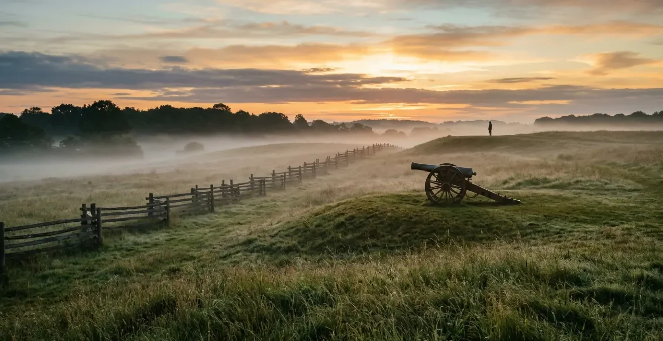
For a beginner, the choice of your first major battlefield can make or break your interest in the Civil War. While Gettysburg is the most famous, its sheer scale and complexity can be overwhelming. The battle unfolded over three chaotic days, involving over 165,000 soldiers across 25 square miles. Trying to grasp its sprawling narrative, from Little Round Top to Pickett’s Charge, can feel like trying to drink from a firehose.
This is why, for many novices, Antietam is the more accessible and impactful starting point. The primary reason is its narrative simplicity. The Battle of Antietam was the bloodiest single day in American history, a brutal, concentrated 12-hour clash. Its story is largely chronological and contained, moving through three distinct phases: the morning fight in the Cornfield, the mid-day struggle at the Sunken Lane (or “Bloody Lane”), and the afternoon assault on Burnside’s Bridge. This linear progression is far easier to follow on the ground than the multi-day, multi-front confusion of Gettysburg.
The physical layout of Antietam, as the view above suggests, is also more contained, making a driving tour highly effective. Most visitor centres are the essential first stop, providing orientation films and maps that lay out the day’s events. From there, a well-marked auto-tour route allows you to experience the battle in the order it happened. While Gettysburg often requires more walking to fully appreciate key positions, Antietam can be meaningfully understood in about five to six hours. This allows for deep immersion without the exhaustion that a full two-day exploration of Gettysburg can entail for a first-timer.
By starting with Antietam’s powerful and digestible story, you build a foundation of understanding and confidence that will make a future visit to the epic scale of Gettysburg all the more rewarding.
How to Hire Specialised Military Historians for Private Battlefield Car Tours?
While apps and audio tours are valuable tools, nothing unlocks the hidden drama of a battlefield like a skilled guide. A private military historian does more than just point out monuments; they act as a translator, turning the silent landscape into a gripping narrative. They can stand you in a specific spot and explain the terrifying choices a regimental colonel had to make, point out a subtle dip in the terrain that provided crucial cover, and answer your questions in real-time. This is the fastest way to achieve a deep, personal connection with the events.
Hiring a guide transforms a passive sightseeing trip into an active, Socratic dialogue with the past. As one visitor, Col. Garth Holmes, noted after a tour with Stephen Ambrose Historical Tours:
The tour was more than I had expected. It was a moving experience to actually walk the ground and have the battles, events and sites explained in a clear and understandable manner.
– Col. Garth Holmes, Stephen Ambrose Historical Tours Review
The key is finding the right guide for you, a novice. Not all historians are great teachers. You need someone who is not just an expert, but an enthusiastic storyteller. The best way to vet a potential guide is to ask questions that reveal their approach to teaching. Don’t be afraid to interview them before booking.
Your Checklist for Vetting a Battlefield Guide
- Assess their teaching style: Ask, “How do you make complex military tactics accessible to complete beginners?” This reveals if they can avoid jargon and focus on the human story.
- Test their narrative ability: Request, “Can you focus on the stories of specific individuals or units rather than just troop movements?” This shows if they can make history personal.
- Check their commitment: Inquire, “What pre-tour materials do you recommend to maximize our time together?” A great guide will want you to be prepared.
- Clarify their scope: Question, “Do you specialize in a single battlefield, or can you connect events across a multi-day campaign?” This ensures their expertise matches your itinerary.
- Verify their credentials: Ask, “Are you a federally Licensed Battlefield Guide (for sites like Gettysburg) or an independent military historian?” This helps determine their level of certification and expertise.
Finding the right person will be the single most effective way to ensure the history of the landscape is revealed to you in its full, dramatic context.
When to Follow the Historical Campaign Timeline Rather Than the Fastest Route?
Modern GPS navigation is a marvel of efficiency, designed to get you from Point A to Point B as quickly as possible. But when planning a historical road trip, the fastest route is almost always the least rewarding. Following the major interstates means you are travelling in a sterile corridor, completely disconnected from the landscape and the strategic decisions that shaped the past. The real magic happens when you trade efficiency for authenticity and choose to follow a narrative chronology.
This means tracing the actual paths the armies took. Why did they cross a river at this specific ford? Why did they clash in this particular mountain gap? These questions can only be answered by getting off the motorway and onto the old state roads and country lanes. This approach treats the landscape as a character in the story. A mountain is no longer just a scenic backdrop; it’s a formidable obstacle that an army had to bypass or fight its way through. A winding river is not an inconvenience; it’s a defensive line that dictated the entire flow of a campaign.
Case Study: Lee’s 1862 Maryland Campaign Route
Instead of taking the modern interstate from Virginia to the Antietam battlefield, consider tracing General Robert E. Lee’s actual invasion route. Start where his Confederate army crossed the Potomac River at White’s Ford, then drive on to Frederick, Maryland. From there, you can follow the roads through the gaps in South Mountain where crucial delaying actions took place. This historical route reveals the strategic choke points and difficult terrain that are completely invisible from the highway, giving you a profound appreciation for the logistical and tactical challenges both armies faced before they ever reached Antietam.
Following a campaign route requires more time, but the payoff in understanding is immense. It adds a layer of depth that transforms the trip from a series of disconnected sites into a single, coherent story. According to Civil War road trip planning guidelines, this method might add 20-30% more driving time, but it can provide 80% more contextual understanding of the campaign’s events. You begin to think like a 19th-century general, not a 21st-century tourist.
This deliberate, slower-paced exploration allows the landscape to tell its story, revealing the “why” behind the “where” in a way no museum ever could.
Why Treating US States Like European Countries Causes Massive Scheduling Disasters?
One of the most common and costly mistakes European visitors make when planning a US road trip is underestimating the sheer scale of the country. A British tourist might look at a map and think driving from Gettysburg, Pennsylvania to Richmond, Virginia is like driving from London to Manchester—a manageable half-day trip. In reality, you are crossing multiple states, and the distances are far greater than they appear. This “geographic scale shock” can lead to exhausting, rushed itineraries where you spend more time in the car than at the historic sites.
A US state is not a European country. Texas alone is larger than France. Driving from Atlanta, Georgia, to Vicksburg, Mississippi, is like driving from Berlin to Prague. To avoid burnout, you must think in terms of driving hours, not just miles, and be realistic about what can be accomplished in a single day. A good rule of thumb is to limit your major travel days to one key site and no more than 4-5 hours of driving. Trying to “bag” multiple battlefields in a single day, especially if they are hours apart, is a recipe for a superficial and frustrating experience.
The table below puts these vast distances into a more familiar European context, making it clear why a different planning mindset is required. A drive that seems routine in Europe can be a major expedition in the US.
This comparative data, based on an analysis of common Civil War routes, highlights the massive scale. A smart strategy to combat this is to use “hub cities” like Nashville for the Western Theater or Richmond for the Eastern Theater. You can base yourself in one city for several nights and take day trips to surrounding battlefields, which avoids the exhaustion of packing and unpacking every single day.
| US Route | Distance | European Equivalent | Drive Time |
|---|---|---|---|
| Nashville to Shiloh | 120 miles | London to Birmingham | 2.5 hours |
| Gettysburg to Richmond | 165 miles | Paris to Brussels | 3.5 hours |
| Atlanta to Vicksburg | 340 miles | Berlin to Prague | 5.5 hours |
| El Paso to Houston | 745 miles | Paris to Warsaw | 11 hours |
By respecting America’s geography and planning a more relaxed, hub-based itinerary, you’ll ensure your trip is an enjoyable exploration, not a frantic marathon.
Gore-Tex Jackets or Traditional Ponchos: Which Protection Works Best in Heavy Rain?
A sudden downpour can quickly turn a fascinating battlefield walk into a miserable slog. Choosing the right rain gear is essential for staying comfortable and engaged, but the choice between a modern technical jacket and a classic poncho isn’t as simple as it seems. Your decision should be based on the terrain you expect to encounter and your tolerance for wind and noise.
Modern waterproof-breathable jackets, often using materials like Gore-Tex, are the gold standard for mobility. Their tailored fit allows for excellent arm and body movement, which is crucial when scrambling up a rocky outcrop like Little Round Top at Gettysburg. They also offer superior wind resistance, staying close to the body in the open fields common to many battlefields, whereas a poncho can act like a sail, flapping wildly and loudly in a gale. The downside is that they require a separate cover for your backpack and can feel less ventilated than a poncho.
The traditional poncho, on the other hand, offers an unbeatable combination of ventilation and coverage. It drapes over you and your backpack, creating a tent-like effect that keeps everything dry and allows for fantastic airflow. However, this same loose fit makes it prone to snagging on branches in wooded areas and, as mentioned, makes it a liability in high winds. The constant flapping can also be a significant source of noise, detracting from the quiet contemplation a battlefield visit often calls for.
For a comprehensive waterproof system, your footwear is just as critical. Even the best jacket is useless if water pours in through your boots. According to recent field testing of hiking rain gear, pairing waterproof boots with a good set of gaiters is incredibly effective, preventing up to 95% of water entry compared to just 60% for boots alone.
To help you decide, this table breaks down the key differences based on data from hiking gear experts.
| Feature | Gore-Tex Jacket | Traditional Poncho |
|---|---|---|
| Mobility on rocky terrain | Excellent arm movement | Can snag on obstacles |
| Backpack coverage | Requires separate pack cover | Covers pack completely |
| Wind resistance | Stays close to body | Acts like sail in open fields |
| Breathability | Good with pit zips | Better natural ventilation |
| Noise factor | Synthetic swishing sound | Loud flapping in wind |
For most varied battlefield terrain, a technical jacket offers the best balance of protection and mobility, but if you’re on a tight budget or anticipate only light showers and flat terrain, a poncho remains a viable option.
Key takeaways
- The key to a fascinating trip is planning for narrative, not just ticking off famous locations. Follow the story of a battle.
- Respect the immense geography of the US. Underestimating distances leads to exhaustion and a rushed, superficial experience. Use hub cities.
- Your physical comfort is paramount. Being properly equipped for the weather (heat, rain, insects) allows you to stay mentally and emotionally engaged with the history.
How to Develop Essential US Geographic Awareness Before Planning Your Holiday Route?
Now that you understand the pitfalls of poor planning, it’s time to build the master skill for a successful road trip: geographic awareness. This isn’t just about looking at a road map; it’s about understanding the land in three dimensions and seeing it as a 19th-century general would have. The best way to do this is by using a “three-layer map” method, which combines physical, modern, and historical data to create a complete picture.
This systematic approach ensures you understand both the historical context and the modern practicalities of your journey. It prevents the “geographic scale shock” and connects you to the terrain in a way that a simple GPS route never could. It’s the final and most crucial step in transforming yourself from a passive tourist into an active historical explorer, ready to read the rich, complex stories written upon the American landscape.
- Layer 1: The Physical Map. Before anything else, study a physical relief map (easily found online). Look for the mountain ranges, the river valleys, and the coastal plains. This is the foundational layer. You’ll immediately start to see why armies moved through certain corridors—like the Shenandoah Valley—and why battles were fought for control of specific high ground or river crossings. This layer reveals the strategic landscape.
- Layer 2: The Modern Logistics Map. Now, switch to a tool like Google Maps. Your goal here is purely practical. Calculate realistic driving times between the battlefields on your wish list. Identify potential “hub cities” (like Richmond or Nashville) that can serve as a base for several days. Use Street View to preview the roads leading to a site—are they narrow country lanes? Is there ample parking? This layer ensures your plan is logistically sound.
- Layer 3: The Historical Overlay Map. This is where you connect history to place. Use resources like the American Battlefield Trust’s interactive maps. These overlays show you exactly where the battle lines were drawn on the modern landscape. You can see troop movements, key landmarks, and preserved areas. This layer allows you to pinpoint the exact spots you want to stand to get the best understanding of the battle’s flow. It turns an abstract historical event into a tangible, visitable location.
Begin your journey into America’s past. Start by applying this three-layer mapping method to the battlefield that intrigues you most, and watch as the silent landscape comes alive with stories waiting to be discovered.