The biggest mistake British tourists make planning a US road trip isn’t what they pack, but their fundamental, and costly, misunderstanding of American scale.
- A “6-hour drive” on Google Maps is a full day’s travel once you factor in fuel, food, and sanity breaks.
- Many US states are not like countries; they are vast, empty regions where you can drive for hours without seeing a single service station.
Recommendation: Stop ticking off state names. Plan your journey by ruthlessly budgeting your driving hours against your ‘experience’ hours to build a trip that is memorable, not miserable.
The classic American road trip. It’s a powerful idea, fuelled by a century of cinema and music. You picture yourself cruising down an open highway, windows down, music blasting, the landscape unfolding before you. For many British travellers, it’s the ultimate holiday. The problem is, this romantic vision often crashes headfirst into a brutal reality: the sheer, uncompromising scale of the United States. You wouldn’t try to visit London, Paris, and Rome in three days by car, yet many apply this same flawed logic to the US, plotting itineraries that look feasible on a map but are physically and mentally punishing.
The common advice to “plan ahead” or “use a GPS” is dangerously simplistic. It ignores the core issue. The hard truth is that planning a successful US road trip is less about where you want to go and more about what you are willing to give up. It’s an exercise in strategic resource management, where your most valuable assets are daylight and your own energy. This guide isn’t about telling you where to go. It’s a pragmatic, blunt corrective to the common misconceptions that turn dream trips into exhausting logistical nightmares. It’s about giving you the geographic awareness to trade an impossible checklist for a genuinely incredible experience.
This article will provide a structured reality check, breaking down the critical planning mistakes and offering practical frameworks to avoid them. We will cover everything from calculating realistic drive times to understanding the cultural and legal quirks that vary from state to state.
Summary: A Pragmatic Guide to US Geographic Reality for UK Travellers
- Why Treating US States Like European Countries Causes Massive Scheduling Disasters?
- The Time Zone Miscalculation That Makes UK Tourists Miss Expensive Internal Flights
- How to Calculate Realistic Daily Driving Distances Across Vast American Landscapes?
- GPS Navigation or Physical Maps: Which Tool Prevents Getting Lost in Remote Areas?
- When to Factor in Desert Driving Fatigue During Your Cross-Country Adventure?
- Why Attempting to Drive Across Five States in One Week Always Ends in Burnout?
- How to Research Specific State Traffic Regulations Before Hiring a Rental Car?
- How to Plan a Seamless Journey Through Multiple US States Without Exhaustion?
Why Treating US States Like European Countries Causes Massive Scheduling Disasters?
The most fundamental error UK travellers make is projecting European geography onto America. You can drive across several European countries in a day. In the US, you can often drive all day and still be in the same state. Texas is larger than France. California is larger than Italy. This isn’t just a fun fact; it has profound implications for your itinerary. The distance between cities is vast, but more importantly, the space *between* points of interest can be startlingly empty.
This concept of “emptiness” is alien to most Europeans. States like Wyoming are a prime example of this scale difference. While the UK has a dense network of towns, villages, and service stations, large parts of the American West are considered ‘service deserts’. For instance, Wyoming has less than 1 person per square mile in many counties. This means no petrol stations, no restaurants, no hotels, and often no mobile phone service for hundreds of miles. Treating a drive through Wyoming like a drive from London to Manchester, where services are always just a few miles away, is a recipe for disaster. Your “daylight budget” gets consumed not just by driving, but by the constant, low-level anxiety of planning for the next fuel stop.
This misinterpretation of scale leads directly to scheduling catastrophes. You might budget six hours for a drive, only to find the lack of services forces longer, less frequent stops, turning it into a nine-hour ordeal. This eats into the time you allocated for sightseeing, creating a domino effect of stress and rushed experiences for the rest of your trip. The first step to a successful plan is to stop thinking of states as countries and start seeing them as vast, sparsely populated regions.
The Time Zone Miscalculation That Makes UK Tourists Miss Expensive Internal Flights
Beyond the sheer physical distance, America’s scale manifests in another trap for the unwary: time zones. The country is divided into six standard time zones. Driving east, you lose an hour at each boundary. Driving west, you gain one. This seems simple enough, but it becomes a major source of error when your itinerary is packed too tightly. Arriving an hour late for a non-refundable hotel booking or a timed-entry ticket to a national park is a common and frustrating mistake.
The problem is compounded by daylight saving time, which is not observed uniformly. The most notorious example is Arizona. It operates on Mountain Standard Time all year round, but the surrounding states of Utah and New Mexico “spring forward” for daylight saving. This creates a bizarre time vortex for travellers. For half the year, a short drive from Utah into Arizona means you suddenly gain an hour. This can be a lifesaver or a trip-killer, especially if you have a flight to catch from Phoenix or Las Vegas. Missing an expensive internal flight because your phone auto-adjusted—or failed to—is a holiday-ruining blunder.
The following table breaks down the core risks and how to mitigate them. It’s not just about knowing the zones exist, but actively planning around their impact.
| Direction of Travel | Time Impact | Common Mistakes | Prevention Strategy |
|---|---|---|---|
| Eastbound | Lose 1 hour per zone | Arriving late for reservations | Book activities 1 hour later than seems necessary |
| Westbound | Gain 1 hour per zone | False sense of extra time leads to late departures | Manually set phone to destination time zone upon starting the day’s drive |
| Arizona crossing | Variable by season | Missing flights due to DST confusion | Before crossing the border, check the current UTC offset for both locations |
Do not rely on your smartphone to handle these transitions flawlessly, especially in areas with spotty service. A physical watch and a pre-trip check of your route against a time zone map are your best insurance policies. Assume nothing and verify everything.
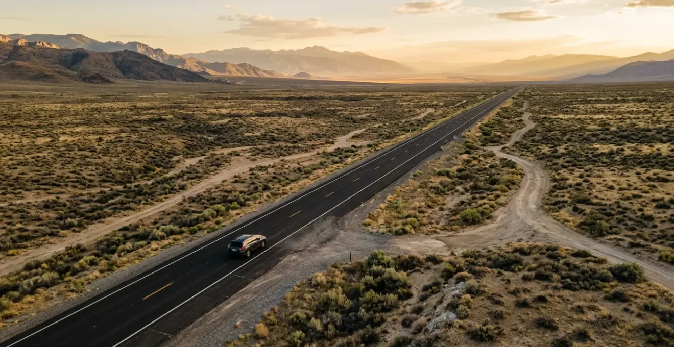
How to Calculate Realistic Daily Driving Distances Across Vast American Landscapes?
The single most destructive tool for a first-time US road trip planner is an unadjusted Google Maps estimate. When it says “6 hours,” your brain, conditioned by UK motorways, thinks, “Right, we’ll be there for a late lunch.” This is a catastrophic error. In the US, a “6-hour drive” effectively consumes an entire day of your holiday. You must apply a ‘Reality Multiplier’ to every estimate.
The journey itself is not the same. UK driving involves frequent roundabouts, junctions, and towns that keep you engaged. A cross-country US highway can be a hypnotic, monotonous straight line for hours, inducing fatigue far more quickly. Furthermore, the infrastructure is built on a massive scale; a simple fuel and coffee stop isn’t a quick pull-off but a major exit, a drive to the service area, and a return, easily consuming 30 minutes. The $634 billion invested in the Interstate Highway System created an engineering marvel for transit, not a scenic route for leisurely stops. This system is designed for long-haul efficiency, which means amenities are clustered at major exits, not sprinkled along the way.
As the image suggests, the romantic idea of the open road must be balanced with the practical realities of time lost to stops. To avoid planning a trip that leaves you with no time to actually see anything, you must adopt a more defensive and realistic calculation method from the outset.
Your Google Maps Reality Check Formula
- Take the Google Maps driving time estimate as your baseline.
- Add 10% to the total time for any route primarily on Interstate highways to account for fuel and basic rest stops.
- Add 25% for scenic routes on mountain or winding coastal roads, where average speeds are much lower.
- Add a punishing 40% for any route that passes through a major metropolitan area (like Los Angeles, Chicago, or Atlanta) between 7 AM and 7 PM.
- Apply the ‘3-Stops Minimum’ rule: for any drive over 2 hours, add a non-negotiable 60-90 minutes for two brief stops and one proper meal break.
GPS Navigation or Physical Maps: Which Tool Prevents Getting Lost in Remote Areas?
In an era of smartphones, relying solely on GPS for navigation seems logical. In the context of a US road trip, it’s reckless. The primary reason is the existence of vast “service deserts” where you will have zero mobile signal for hours on end. This isn’t a rare occurrence; it’s a certainty in national parks and on long stretches of highway in states like Nevada, Utah, Montana, and Arizona.
If you haven’t pre-downloaded offline maps for the entire region (which consumes significant phone storage), your GPS will become a useless brick the moment you need it most. This is how tourists get dangerously lost. As travel publisher Rand McNally emphasizes in its guides, carrying a physical, up-to-date road atlas is not a nostalgic gesture; it is an essential piece of safety equipment. The case of Death Valley is a stark warning: its remote areas can have no cell service for stretches exceeding 100 miles, making paper maps the only reliable tool for navigation and identifying potential side roads or ranger stations.
The optimal strategy is not to choose one over the other but to use them in synergy. Use your GPS for what it excels at: real-time traffic in cities and final-mile directions to your hotel. Use your physical map for the macro-level view: understanding the day’s route, identifying alternative paths, and maintaining a sense of your overall location when technology fails.
| Tool | Best Use Case | Limitations | Essential For |
|---|---|---|---|
| GPS Navigation | City intersections, final-mile directions | Requires cell signal or pre-loaded maps | Urban navigation, real-time traffic |
| Physical Maps | Route overview, alternative paths | No real-time updates | Remote areas, backup navigation |
| Offline Maps | No-signal areas with phone GPS | Storage space, regular updates needed | All travel west of the Mississippi River |
Before you depart, buy a comprehensive, current-year Road Atlas of the United States. It’s the best £20 you will spend on your entire trip.
When to Factor in Desert Driving Fatigue During Your Cross-Country Adventure?
Driving fatigue in the US is a different beast from what you experience in the UK. One of its most potent and underestimated forms is “highway hypnosis,” especially prevalent in desert landscapes. The combination of a perfectly straight road, a constant engine drone, and a monotonous, unchanging view for hours on end can lull a driver into a dangerous, trance-like state. Your reaction times plummet, and the risk of a serious accident skyrockets.
This isn’t just about feeling a bit tired; it’s a cognitive impairment caused by a lack of stimuli. The blazing sun and heat shimmer on the horizon only intensify the effect. You must proactively fight it. This involves more than just pulling over for a coffee. It requires a strategic approach to managing your mental state during long desert drives, which are unavoidable on any cross-country itinerary through states like Arizona, Nevada, Utah, or eastern California.
Your plan must include specific countermeasures. This includes curating your in-car audio, scheduling mandatory breaks regardless of how you feel, and managing your physical well-being. Hydration is particularly critical; even mild dehydration, which occurs rapidly in a hot car, can severely impair judgment. You need to prepare for these drives as if you are preparing for a minor endurance event.
- Switch Your Audio: Combat hypnosis by swapping rhythmic music for engaging podcasts, audiobooks, or talk radio. The variation in human speech patterns keeps your brain more active.
- The 90-Minute Rule: Set a timer and force yourself to stop every 90 minutes. Get out, stretch, walk around for five minutes. It breaks the monotony and resets your focus.
- Hydration and Snacks: Start hydrating two hours before the drive begins. Keep a cooler in the car with at least one gallon of water per person and electrolyte packets. Avoid sugary snacks that lead to an energy crash; opt for protein-rich alternatives.
- Sun Glare Management: Plan your driving direction relative to the time of day. Driving east into the rising sun or west into the setting sun creates debilitating glare. Wear high-quality polarized sunglasses.
Why Attempting to Drive Across Five States in One Week Always Ends in Burnout?
A common ambition for first-timers is to “collect” as many states as possible. The “Five States in Seven Days” plan is a classic example that almost always results in experience burnout. The flaw lies in ignoring the hidden time costs of daily relocation. You are not just driving; you are packing, unpacking, checking in, checking out, and finding food. Veteran travel experts calculate that a ‘6-hour drive’ actually consumes 9.5 hours of daylight when you factor in these administrative tasks and essential stops.
When your itinerary consists of back-to-back 6-hour drives, you have effectively planned a trip where you do nothing but drive, eat at service stations, and sleep. The destinations become a blur. You’ll have photos to prove you were there, but the memories will be indistinct because you never had the time or mental space to properly absorb the experience. This frantic pace is the fastest way to turn an adventure into a chore.
Case Study: The East Coast vs. West Coast Five-State Fallacy
The very concept of a “five-state trip” is meaningless without geographic context. A one-week journey through five small East Coast states like Rhode Island, Connecticut, Massachusetts, New Hampshire, and Vermont is perfectly manageable and enjoyable. The total driving distance is reasonable. However, applying the same logic to the West is a recipe for disaster. A five-state trip through California, Nevada, Arizona, Utah, and Colorado covers a landmass roughly the size of Western Europe. Attempting this in a week isn’t ambitious; it’s a physical impossibility that guarantees exhaustion and a complete lack of enjoyment.
The goal should be depth, not breadth. The “binge-watching” analogy is useful: savour each destination like an individual episode of a great series. If you rush through, you’ll miss the plot and character development. To prevent this, build mandatory ‘rest days’ into your plan, where the car stays parked, allowing you to actually enjoy the place you worked so hard to reach.
Key Takeaways
- The US is not just big, it’s empty. Plan for “service deserts” with no fuel or mobile signal for hundreds of miles.
- Your GPS lies. A “6-hour” drive is a full day. Add a minimum of 25-40% to any estimate to account for real-world stops and traffic.
- State-counting is a trap. A five-state trip in the West is like trying to tour Western Europe in a week. Focus on regional depth, not breadth.
How to Research Specific State Traffic Regulations Before Hiring a Rental Car?
One of the final layers of complexity in a multi-state US road trip is that traffic laws are not federal; they are set at the state level. While most rules are consistent, the variations can be subtle, confusing, and expensive for foreign drivers. Getting a hefty fine or, worse, having a minor accident due to a misunderstanding of local rules is an easily avoidable stress.
You do not need to become a legal expert, but you must research the handful of rules that most commonly trip up drivers from the UK. These often relate to right-of-way at junctions and specific situations not typically encountered on British roads. A quick 10-minute search for “driving rules in [State Name] for foreigners” before you enter a new state is a crucial habit to develop.
Three of the most costly and common mistakes for foreign drivers are:
- Right Turn on Red: In most states, it is legal to turn right at a red light after coming to a complete stop, unless a sign explicitly forbids it (“No Turn on Red”). This is completely alien to UK drivers and a frequent source of angry honking from local drivers behind you.
- 4-Way Stop Signs: When four roads meet at an intersection with stop signs for everyone, the rule is “first to arrive, first to go.” If two cars arrive simultaneously, the car on the right has the right-of-way. This requires a level of eye contact and unwritten social negotiation that can be baffling at first.
- School Bus Laws: This is the most serious. If a yellow school bus stops and displays flashing red lights and a stop sign, all traffic in both directions must stop completely. Overtaking a stopped school bus carries severe penalties, including massive fines and potential license suspension.
Beyond driving etiquette, practical systems like road tolls also vary. In the Northeast, you’ll likely need an E-ZPass transponder for tolls, while in Florida, it’s the SunPass system, and in Texas, you’ll encounter the TxTag system. Your rental car company should offer a tolling solution, but you need to ask about it and understand its cost before you drive off the lot.
How to Plan a Seamless Journey Through Multiple US States Without Exhaustion?
So, how do you combine all this awareness into a practical, enjoyable plan? The solution is to abandon rigid, minute-by-minute itineraries and adopt a more flexible, strategic framework. The most successful multi-state road trips are built on a simple principle: Anchor & Float. This method provides structure without sacrificing the potential for spontaneous discovery.
The process is straightforward. First, select 2-3 non-negotiable “Anchor” destinations—the absolute must-sees of your trip (e.g., the Grand Canyon, New Orleans, Yellowstone). These are your fixed points. Next, use the ‘Reality Multiplier’ to calculate the realistic driving days, or “Transit Days,” required to travel between these anchors. The remaining days in your holiday are your “Float Days.” These are your buffer, to be used for spontaneous stops at interesting-looking small towns, for an extra day at an anchor you’ve fallen in love with, or simply for rest.
This approach kills the tyranny of the over-stuffed schedule. A key component of this is the intentional scheduling of “Zero-Mileage Days.” For every 3-4 days of significant driving, plan one full day where the car does not move. This is your day to do laundry, explore a city on foot, or simply sit by a hotel pool and decompress. It’s on these “zero days” that the experiences truly sink in and the “experience burnout” is kept at bay. Your trip should be planned around a coherent theme (e.g., a “National Parks Tour” or a “Music History Journey”) rather than an arbitrary list of states.
Stop dreaming and start calculating. Use these principles to build a US road trip itinerary that delivers the adventure of a lifetime, not the exhaustion of a poorly planned commute. Your journey’s success is now in your hands.